"" /> HADEJIA A YAU!

Ismaila A sabo Hadejia

Ismaila A sabo Hadejia
(1)Wannan dai shine Hotona, wadda Idonku yake kallona. (2) Bayan na tafi gun Sarkina, zaku tuna ni watan wata rana. (3) In wani yayi kiran sunana, sai ku cane Allah yaji kaina. (4) Koda zakuyi jimamina, sai ku yimin addu'ah bayana. Marigayi Aliyu Akilu.

Saturday, October 9, 2021

ARAB'S ORIGINS AT GARUN-GABAS. BY F. W. H. MIGEOD.

HADEJIA A YAU!

Arab Origins at Garun Gabbas.

By F. W. H. MIGEOD... 1911..


A noticeable feature among the peoples west of Lake Chad is that many claim an origin from Arabia and chiefly Yemen.This means little more than that a leader arose who migrate a number of followers by slave raiding and the prospect of loot, in the same way as Rabeh did at the end of the 19th century. The legends of this stream of migration are so persistent that an authentic genealogy proving it in at least one instance is of value in support of the general claim; and this is supplied by the town of Garun Gabbas. Many of the migrations appear to have had their origin in the refusal of certain persons and families to accept Mohammedanism, but whether the Arab tribes on the eastern side of Lake Chad owed their presence there to the same cause is another matter. In any case, Arab infiltration across Africa from the Red Sea and the Nile to Lake Chad did not begin in recent centuries.


 The small town of Garun Gabbas is about 12 miles north of Hadejia. The present Bulama or Headman (Bulama is a compound Bornu word, meaning Town Headman) named Musa claims to be of Arab descent and of a long line of kings. In appearance he is jet black, but with white whiskers, and I found nothing to distinguish him from a pure negro, except, perhaps, some slight difference of manner. One felt there was a distinction. He said he was not a Shuwa Arab, the Arab tribe living to the south of Lake Chad, but an Arab from Sham, ie., Syria, and the line of migration of his ancestors was Sham, Kanem, Bornu, Kulumpardu or (Kulunfardu), and thence to Garun Gabbas. His wife was Fula and his children by her spoke the language of their mother. His mother and grandmother were both Bornuese. He went the pilgrimage to Mecca before Rabeh's time, and was 5 years away, he reckoned his present age of 55.


The founder of Garun Gabbas was one Ibrahim, and members of the same family went and founded the now more important city of Daura. Inhabitants of Garun Gabbas wore possibly largely Arab, the leader of the colonists was a Beriberi (i.e. Bornuese), known to them by the name of Zanoa, but his real name was not known. Zanoa's family no longer exists. The reason of the migration out of Bornu was that Ibrahim had a dispute with Mallam Mukhtar, his elder Although the early brother. He came along peacefully and there was no fighting. Although a Beriberi was the leader of the colonists, Garun Gabbas was never under the rule of Bornu. Nevertheless the inhabitants are said to have used the Kanuri language (the language of Bornu) in the days before the founding of Daura, the date of which I have not been able to ascertain with any degree of acouracy. 


The reason probably was that owing to the preponderating influence of the Bornu empire as far back as the thirteenth century, and possibly earlier, the Kanuri language became and still is very widely used. In any case the Bornu influence is reputed to have been very strong in Garun Gabbas. An unexplained detail is why Zanoa does not appear in the list of kings. There are twenty of the ancient families said to be still represented in the country. Some of the inhabitants had in recent years married Beriberi women, but Beriberi men had not settled there in great numbers. The Town is now very small compared with what it was formerly. The present population is Fula, it had spread even to within a few miles of Kano.


Garun-gabas is a small town compared with what it was formerly. The present population is Fula, Awuyokawa (related to the Bedde), and some Beriberi, the Fula being in the largest numbers. The old record of the kings was burnt accidentally six years ago (say 1916). I was told, but a new one had been written out containing all they could remember.


In the original list was the number of years each king had reigned, but they could not be reproduced. The first on the list is Ibrahim who came out of Bornu, it is said they were Mohammedans then and brought horses and asses, but not cattle. 


 As to the town, the old mud wall is now scarcely discernible. The Headman's house is surrounded by a high mud wall, but all the other houses are of grass and circular in shape. There are some baobab trees about that at the rest house being 35 feet in circumference. The soil between Hadejia and Garun Gabbas is dark grey clay, except where crossed by the numerous east to west sand ridges. On the low ridge on which stands the rest house lies a little quartz gravel of very small size, which was the first i had seen on my westward journey from Lake Chad. A depth of twenty-two fathoms.


LIST OF KINGS OF GARUN GABBAS FROM A MANUSCRIPT. 


ARABS…. 

1. Ibrahim
  1. 2. Maji

  2. 3. Kulada

  3. 4. Yerima

  4. 5. Kimeri

  5. 6. Donkofo

  6. 7. Jatou

  7. 8. Amale

  8. 9. Mammadu

  9. 10. Donko

  10. 11. Yahaya 

  11. 12. Dan Asawa

  12. 13. Aburi

  13. 14. Sakaina

  14. 15. Musa

  15. 16. Kujeilu

  16. 17. Adam

  17. 18. Aliyu

  18. 19. Tagwoi

  19. 20. Jimami

  20. 21. Balikurugu

  21. 22. Issaku


FULANI...

 23. Baruwei 

24. Gauyama 

25. Bouri 

26. Ousmanu 

27. Abdu 

28. Abdu 


SLAVE OF KING OF HADEJIA. A pagan.. 


29. Baluwa


ARABS grandfather of present man. 


30. Muhamman Bako


FULANI… 


31. Tukur 

32. 

Buba 

33. Kawu 

34. Alhaji Abubakar. father of the present man 

34. Musa. Present man 1922.


Reference....... MAN A MONTHLY RECORD OF ANTHROPOLOGICAL SCIENCE.

PUBLISHED UNDER THE DIRECTION OF THE ROYAL ANTHROPOLOGICAL INSTITUTE OF GREAT BRITAIN AND IRELAND.

PUBLISHED BY THE ROYAL ANTHROPOLOGICAL INSTITUTE 50, GREAT RUSSELL STREET, LONDON, W.C.I. General Agent: FRANCIS EDWARDS, 83, High Street, Marylebone, W.l,New York Agents: Messrs, G. E. STECHERT & Co.


Tuesday, June 15, 2021

GANUWAR HADEJIA DA KOFOFIN TA...

HADEJIA A YAU!


Garin Hadejia gari ne wadda ganuwa ta kewaye shi, sannan yana da kofofin shiga guda biyar. 

In muka duba Report din Lugard akan Africa wanda yace "Duk kasar Hausa babu gari kamar hadejia wajen jarunta da rundunar mayaka majiya karfi, akwai ganuwa a zagaye da garin masu kofofi guda biyar masu karfin gaske wanda harsashin bindiga bazai iya fasa kyauran kofar ba." Lugard Ya rubuta wannan magana acikin (kundin Najeriya ta Africa shafi na 247). Wanda yake ajiye a dakin da ake ajiye kayan tarihi na Najeriya ta Africa a Arewa House Kaduna.

A wata wasika da Captain Philips H. C. B. ya rubutawa Colonel Larymore ranar 17 December, 1903. Inda yace. 
 "HADEJIYA BUBBAN GARI NE SOSAI KUMA TANA DA GAWURCACCIYAR GANUWA MANYA-MANYA MASU KYAU SOSAI A  ZAGAYE DA GARIN MAI TSAWO KIMANIN KAFA TALATIN GABA DA BAYANTA, TA KO INA A ZAGAYE DA ITA AKWAI KOFOFI GUDA BIYAR KADAI, ITA KANTA GANUWAR KAURINTA YA KAI KAFA TALATIN DAGA KASA. KYAMAREN KOFOFIN MASU KARFI NE SOSAI YADDA HARSASHIN BINDIGA BAZAI IYA FASA SHI BA CIKIN SAUKI, YAWAN JAMA'AR DA KE CIKIN GARIN SUN KAI KIMANIN DUBU TAKWAS ZUWA DUBU GOMA. FADIN GANUWAR GARIN YA KAI KIMANIN MAYIL HUDU DA RABI. GARIN ZAI YI KWATANCI DA KAMAR RUNDUNA, AMMA TA KAI KIMANIN DARI UKU DA HAMSIN (350)."

A Zamanin Sarakunan Habe garin Hadejia bashi da ganuwa sai dai wani abu da ake kira "KAFI", wato wani Asiri ne na kafewa gari wadda abokan gaba bazasu samu nasarar yakar garin ba. Shi kafi ana sanya Layu ne a cikin Tukunya ko a kahon rago da sauran su, sannan a binne a farkon gari da karshen gari ta kowane bangare. A lokacin da Sarkin Hadejia Sambo ya samu nasarar korar Sarkin Hadejia na Habe, bayan ya zauna a gidan sarautar su sai ya sake tsara taswirar fadar sa, inda ya sake gine-gine da soraye da masaukin baki da sauran su. Dalilin da yasa aka samu Kududdufin Atafi kenan, domin anan aka rinka debo ƙasar da aka gina sorayen fada.

Sarkin Hadejia Sambo shine ya gina ganuwa a Hadejia, inda kuma yayi kofofin shiga garin guda hudu. Wannan Ganuwar daga yamma iyakar ta Kofar Jarma, daga kudu kuma Bakin Ramin Atafi kusa da gidan Sarkin Busa. Daga gabas kuma iyakar ta ramin Tankari kusa da Unguwar Hudu, daga gabas kuma iyakar ta Unguwar Dallah. A zamaninsa kuma Fulani suka bar mazaunin su da yake Rinde, can kusa da Gandun Kabo suka dawo cikin garin Hadejia, inda da yawan su sai suka zauna a yamma da gari inda yanzu Unguwar Rinde take. Bayan Sarkin Hadejia Sambo shima Sarkin Hadejia Buhari ya fadada ganuwa ta bangaren Kudu har sai da ta kai kusa da Kogin Hadejia, shima Sarki Haru ya ci gaba da fadada ganuwa har sai da ta kai inda take a yanzu, sannan ta ci gaba da zama kofofin ta guda hudu. 

Kofar Gwani itace Kofar gabas
Kofar Matsaro itace kofar yamma
Kofar Kogi itace kofar kudu
Kofar Barno itace kofar Arewa.

Ganuwa kuma ta zagaye garin domin babu ta inda zaka shiga cikin gari sai ka bi ta kofofin nan. A zamanin Sarkin Hadejia Muhammadu wadda ya gaji Sarkin Hadejia Haru ya sake ginin kofofin nan, inda aka sake musu gini mai kyau a shekarar 1871. Dalilin wannan gini ne ma yasa ake kiran kofar Gabas da suna Kofar Gwani, domin wani magini ne mai suna Gwani ya gina su har ma da Soron fada da ake kira Soron Bubban Gwani.

Itama Kofar Kogi ta sauya suna a zamanin da aka rufewa Sarkin Hadejia Umaru Kofa, saboda ambaton kalmar kyale su da yayi shine yasa ake kiran ta Kofar Kyale su. 

Kofar Barno itama ta sauya suna yanzu an fi kiran ta da sunan Kofar Arewa, dalilin da yasa ake kiran ta da Kofar Barno kuwa shine, saboda Unguwannin da suke kusa da kofar duk mazaunin Barebari ne, irin su Gagurmari, Kilabakori, Kakaburi, Zonagalari da sauran su. 

Itama kofar yamma dalilin da yasa ake kiran ta da suna Kofar Matsaro shine saboda Sarkin Kofar ne ake kiran sa Mai Tsaro, shine ake cewa kofar Mai tsaro daga baya sunan ya sauya ya zama Matsaro. 

Zamanin Yakin Hadejia da Turawa a shekara ta 1906, Turawan sun rusa ganuwa ta Kudu da gari inda suka samu suka shigo Hadejia suka cita da yaki. Bayan an gama yaki ba'a gine wurin da Turawan suka shigo ba, sai aka gyara wurin aka saka masa kyauren kofa, sannan ake kiran kofar da suna Kofar Talata. An yiwa wannan Kofa lakabi da sunan ranar da Turawa suka fasa Ganuwar suka shigo Hadejia, wato ranar Talata.

Bayan shekaru da yawa kuma wannan kofa sai ake kiran ta da suna Kofar Mandara, domin akwai wata mata da ake kira Mandara kullum a wannan kofar take wuni domin tana tura dabbobin ta kiwo tun safe har zuwa yamma. Saboda karuwar Kofar Mandara sai kofofin Hadejia suka zama guda biyar.

Tun zamanin Sarkin Hadejia Haru wadannan Kofofi guda hudu suke da Sarakunan su, wato masu kula da su kenan. Wadda kuma sune suke sarautar Unguwannin da kofofin suke, misali... Mai Unguwar Matsaro shine sarkin Kofar Yamma, haka sauran kofofin duk masu unguwannin wurin sune sarakunan Kofofin.

Sunday, May 30, 2021

SARKIN YAKIN SARKIN MUSULMI NA GABAS...

HADEJIA A YAU!

A lokacin da Sarkin Marma Muhammadu ya dawo daga Sokoto wajen taya Sarkin Musulmi Yakin Madarumfa, jama'ar gari da mahaya Dawaki sun fita taryen sa domin kafin yazo labari ya iske Hadejiawa cewa Sarkin Musulmi ya nada shi Sarautar Sarkin Yakin Sarkin Musulmi na Gabas. Kafin Sarkin Marma ya iso kofar Fada Sarkin Hadejia Haru Bubba ya fito filin fada don jiran isowar Sarkin Marma, ko da ganin Sarki ya fito sai aka sanarwa Sarkin Marma cewa Sarki yana filin kofar fada.

Shi kuwa Sarkin Marma Muhammadu da ya iso kusa da Masallacin Juma'a sai ya tsaya anan, mahaya dawaki suka rinka zuwa suna yi masa Gaisuwa (Jafi). Anan Sarkin Jauje ya shirya masa wata waka da yake cewa...

Wai ina wani ba kai ba zaki wan dawa, 
Uwa hana kukan talaucin duniya,
Mu je mai randa mu debo tulina,
Ina ke gaba ina ke gaba,
Da ku fadawa ku daina haye masa.

Bayan an gama gaisuwa (Jafi) sai Sarkin Marma ya nufi Kofar fada yayi gaisuwa a wurin Sarkin Hadejia Haru Bubba, sannan ya wuce gidan sa ya sauka. Bayan ya zama Sarki a shekarar 1885, sai ya maida wannan Jafin Al'adar hawan sallah, duk sallar Azumi da Layya zai tsaya a kusa da Masallacin Juma'a Hakimai su zo su yi Jafi. Haka Al'adar ta ci gaba har zuwa yau.
Allah ya karawa Masarautar Hadejia daraja da daukaka.

Ismaila A Sabo.


Saturday, October 10, 2020

BATURIYA BIRDS SANCTUARY, HADEJIA WETLAND GAME RESERVE..

HADEJIA A YAU!

BRIEF HISTORY OF THE HADEJIA WETLAND GAME RESERVE, JIGAWA STATE.


INTRODUCTION OF THE GAME RESERVE


Baturiya Birds sanctuary, sometimes referred to broadly as Hadejia Wetland game reserve is a natural wetlands, located within the Sudan Sahelian region. Its stretches in a general west to east direction of Hadejia River Valley touching portion of three Local Government Areas Auyo, Kirikasamma and Guri Local Government areas in Jigawa State.The reserve was taken as Parts of Birds area of Hadejia/Nguru wetland and also as wetland of international importance (RAMSAR) 20  recently it was proposed to upgrade to a state of a national park by Nigerian national parks service (NPS).


The area of the reserve includes; the buffer zone is about 350km2 reserve support great variety of wildlife resources particulariy water game birds that are of both migratory and resident origins especially for resting activities.

HISTORY OF THE GAME RESERVE


The game reserve derived its name from the neighboring community of meaning a lady from Europe or white lady this was originated some centuary back when Baturiya community was not established, the area was just a variety of wildlife resources and Europeans used to visit and camp at. History have indicated that in early 70's the bush around Baturiya terms of variety of wildlife species and there were a lot of pond and were rich in terms of fish, crocodiles, monitor lizard and others aquatic animals.


for this purpose the then emir of Hadejia decided to organize a festival, where fishing and swimming competitions were performed and take place during the period of a festival, the then governor of defunct Kano state (Alhaji Audu Bako) was at the occasion and he became fascinated and attracted with the biodiversity resources of the area.


 For this in 1975 he directed the forestry department, to establish the game reserve in the area. The first survey of the area was carried out in the same year 1975 are surveyed in 1980 and officially gathered as a game reserve in 1985, becoming of game reserve to ascertain the boundary was carried out in the year, 2008, 2011, 2013 and 2016.


PHYSICAL CONDITIONS REGARDS TO FLORA AND FAUNA OF THE GAME RESERVE


Hadejia wetlands game reserve embodies diverse of flora and fauna both of the sahel and sudan savannah type that comprises predominantly of the following species.. 


Acacia nilotica Gabaruwa, Acacia sayel dusa, tamarindus indica tsamiya, mitrigyna inermis Giyayya, Diospyros mespilifornmis Kanya, hypaenia thebaica Goruba, Balanites egyptiaca Aduwa, Acacia albilda Gawo, Acacia seiberiania fararkaya/Bauji, Azadirachta indica Maina/darbejiya, Vitex doniana Dinya, Parkia Biglobosa Dorawa, Zizaphus Maturiania Magarya, Anogesus Leacarpus Marke, Piliostigma reticulatum Kargo, Prosopis Africana Kirya, Acacia Senegal Kayar dakwara, Acacia gurmensis Kama mu raba sterculia stangera Kukkuki, Afzelia Africana Kawo, Afzelia Chavaleri Katsari, Adonsinia Digitata Kuka, Annona Senegalensis Gwandar Daji, Ficus Cycamorus Baure, Gardenia Aqualle Katambiri/Gaude, Khaya Senegalensis Madachi, Mangifera Indica Mango, Sieberiana Runfu, Ficus Eteolphylla Shirinya, Ficus Thonningi Cediya, gulera Senegalensis Sabara, Stereospermum Kunthiamum Samsami, Acacia Tazancantha Sarkakiya, Borassus Aethiopum Giginya, Calotropis Procera Tunfafiya, Bauhinia Rufescana Matsagi/Matsantsagi, Ceiba Pentandra Rimi, Celtis Intergrifolla Zuwo/Dukki Pterocarpus Erinaceus Kattakara/Madobiya Terminelia Evicennioidea Baushe/Kwandari, Ficus Platyphylla Ganji.


The physiognomy of the vegetation within the game reserve also varies, with regards to wild life animals that are commonly spotted in the area includes; redpatas monkey, Baboon spotted Hyena Grims duiker, wathog common Jackal and many species of snakes including rockpython among others.


The abundance of the variety of birth such as game birds and waters birds species with high population which are commonly sighted in the game reserve and includes; GAME BIRDS….. 

Wednesday, October 7, 2020

THE FOUR RULING GROUP OF ZAZZAU.

HADEJIA A YAU!
Four ruling groups of Zazzau Emirate. 


The Province of Zaria was formed in 1902, and during this year Kwassau was deposed for intriguing with the Emir of Kano, who was at that time still hostile to the British. Aliu dan Sidi, of the original Mallawa dynasty, was appointed Emir in 1903. He reigned for twenty years. Victor N. Low. 

In 1902 the three Emirates of Keffi, Nasarawa, and Jemaa, which had previously been tributary to Zaria, were removed from the suzerainty of the Emir of Zaria and made independent.
This was a humiliation for the murder of Captain Moloney at Keffi by the Magajin Keffi, an accredited agent of the Emir Kwassau, who was sheltered first by the Emir of Zaria and then by the Emirs of Kano and Sokoto. They all had bitter cause to regret it.

The Zaria ruling group consisted of four lineages..The Barebari, the Katsinawa, the Mallawa and the Sullubawa, around which local power struggles within the N.A. revolved. These royal lineages were also the only source of candidature for the oflice of emirship, and thus they and their supporters controlled the N.A. in 1950, but the Emir's lineage was always the dominant group.

In 1950 the Emir of Zaria was Malam Ja'afaru, who remained in office until his death in 1959; he belonged to the Barebari lineage. Before his appointment as Emir in 1937, he had served as district head of Zangon Katab for 22 years. In his earlier years as Emir he was said to be more advanced in his outlook than the majority of his contemporaries.

But with the advance of years he found it difticult to adjust to the political changes in the country in the 1950s. Politically, he remained deeply committed to the maintenance of the status quo based on the principles of indirect rule.

Accordingly he did not subscribe to opinion in the Region critical of an N.A. system based on indirect rule. He openly expressed his alarm at the rate of political change in the Region and feared this could undermine the existing administrative framework. In Emir Ja'afaru's view the N.A., as then organized, had done a great deal for the welfare of the people and had protected the common man from the exploitation of 'dishonest officials'. 

In 1959 Ja'afaru was succceded by Muhammadu Aminu, who was a member of the Katsinawa lineage and had served the N.A. first as head of the health departnent, and later was appointed the lya with resporsibility for the Sabon Gari district. 

In this office he had a reputation for openmindedness which enabled him to maintain order in this most cosmopolitan and urbanised sector of the Emirate. Unlike Ja'afaru, Aminu was a contemporary of the leaders of the Northern Peoples Congress, his close personal friendship with the Regional Premier, Alhaji Ahmadu Bello, Sardauna of Sokoto, was believed by many to have been the reason for the Premier giving him the Emirship. 

When Aminu took office in 1959 the N.A. was dominated by the Barebari and thus, during the first 2 years of his appointment he found difficulty in establishing his control.

Reference….. 
The native authority system in northern Nigeria, 1950-70: A study in political relations with particular reference to the Zaria native authority by Yahaya, A. D. Publication date 1980. 

Muhammadan Emirates In Northern Nigeria by Victor N. Low. 


Tuesday, October 6, 2020

FLOOD DISASTER IN HADEJIA, BY DR. MUHAMMAD B. UMAR.

HADEJIA A YAU!

LOST IN DEVELOPMENT’S SHADOW: THE DOWNSTREAM CONSEQUENCES OF TAMING THE HADEJIA RIVER, JIGAWA STATE, NIGERIA 


INTRODUCTION 

In the past century, large dams became a prominent instrument for economic development. Worldwide, the number of large dams stood at 5000 in 1950; three quarters of these were in North America, Europe, and other industrialised countries. By 2000, the number of large dams had climbed to over 45,000 and these were spread among more than 140 countries. On average, two large dams were built per day for half a century. Currently, the number of large dams exceeds 50,000. These dams provide water storage that has enabled large cities like Phoenix, Arizona in the United States, to grow in desert regions. They supply hydropower that has electrified many rapidly expanding industrial and urban economies, from Seattle to Shanghai. Also, large dams are important in agriculture. About half of the world’s large dams were built primarily for irrigation, many of them in Asia as the Green Revolution spread. Today, large dams are estimated to contribute directly to 12-16% of global food production. Definitely, large dams have played an important role in economic development. 

However, large dams have also brought serious environmental and social consequences. Whereas the benefits have generally been delivered to urban centres or industrial-scale agricultural developments, riparian river-dependent populations located downstream of dams have commonly experienced a difficult disturbance of their livelihoods, loss of food security and other impacts to their physical, cultural and spiritual well-being. River flows altered by large dams often disrupt or destroy downstream habitats and life cycle cues for fish and other river species, as well as fishing, cropping and grazing systems that rely on flood-plain socio-ecosystems. While riparian river-dependent communities may benefit from some degree of flood protection and enhanced irrigation opportunities provided by dams, adverse impacts are far more common and usually outweigh the benefits to downstream people, resulting in reduction of their incomes and livelihoods. 

Although, the nature, duration and severity of these impacts vary from one dammed river to another, in some of the cases documented, the wave of social, physical, cultural, spiritual disruption and human health impacts following dam construction largely passed within a decade. In other cases, dam-induced impacts have persisted through multiple generations. In some cases, impacts may be mitigated by alternative sources of food or employment; in other cases, they may not. And in some cases, the environmental effects of dams are detectable for only a short distance downstream, while in others those effects remain significant through hundreds of river kilometres. Nevertheless, what the majority of cases have in common is the failure to account for these impacts and their consequences on downstream populations

These cases prompted me to overtly write on: the perpetual occurrence of flood in the Hadejia Valley; the human and material costs of the damages; little or absence of relief, control, mitigation and management of this man-made disaster and finally nobody seems to know why it periodically happens and the failure to account for these impacts and their consequences on downstream communities. Therefore, I would like to open a forum through this write-up on the downstream human and material consequences of flood in Hadejia, its environment and beyond with a cautionary quote from a report. Thus;


“Any scheme of flood releases from present and projected reservoirs can only be undertaken with a much improved monitoring network of instruments, greatly enhanced levels of training amongst responsible staff, and a very close and effective liaison between the river managers and those who actually use the rivers and their waters.  It is essential that the timing of the releases is correct. Too much water, too early in the season and the planted seed will be drowned.  Too little water, too late and the small rice plants will wither and die before the onset of the flood.  A big reservoir release, when flood conditions already exist from heavy rainfall and large discharges in tributaries, could cause serious damage to bridges and the inundation of towns and villages.  Similarly, it will be essential that the releases in the Hadejia River are carefully coordinated with those in the Jama’are River so as to derive maximum benefit in the wetlands and downstream of Gashua.  Such coordination will require substantial studies of the hydrology of the rivers using daily data, greatly enhanced understanding of the mechanisms of flooding and groundwater recharge, and probably the development of a real time forecasting and control model for the river basin.  So, whilst such a scheme of flood releases may be shown to be technically feasible and economically desirable, it is essential that perhaps a decade of planning and organization be undertaken before any such scheme is implemented.” IUCN Report (1993).

In Nigeria, flood disaster has been perilous to communities and institutions. It has shattered both the built-environment and undeveloped plan. It has claimed many lives, and millions of properties got lost due to its occurrences. One prominent feature about it is that flooding does not discriminate but, marginalizes whosoever refuses to prepare for its occurrence. Flood affects more people on an annual basis than any other form of natural disaster, a variety of climatic and non-climatic processes influence flood processes, resulting in different types of floods. This shows that flooding in Nigeria could be as a result of natural or human cause, categorized as follows: Natural causes;

a. Heavy rainfall, 

b. Oceans storms and tidal waves usually along the coast, 

c. Lack of Lakes, and

d. Silting Human causes. 

While other human causes of flooding in Nigeria may be due to one of the following factors; 

a. Burst water from main pipes, 

b. Dam failures,  

c. Population pressure (especially in the city of Lagos), 

d. Deforestation (such as North part of Nigeria),

e. Trespassing on water storm drains (key cause in Southern Nigeria),

f. Unplanned urbanization (in many cities it’s the key cause of urban flooding), 

g. Poor Sewerage Management,  

h. Neglecting warnings from hydrological system data (major cause of 2012 flooding in Nigeria), and 

i. Lack of flood control measures (especially by government).

Unfortunately, in Northern Nigeria, the construction of dams and other water projects upstream have already affected irreversibly the hydrology of the Hadejia-Jama'are floodplain such as the recent flood release which brings us to delve into the conception of irrigation in the valley area.


THE CONCEPT OF IRRGATION

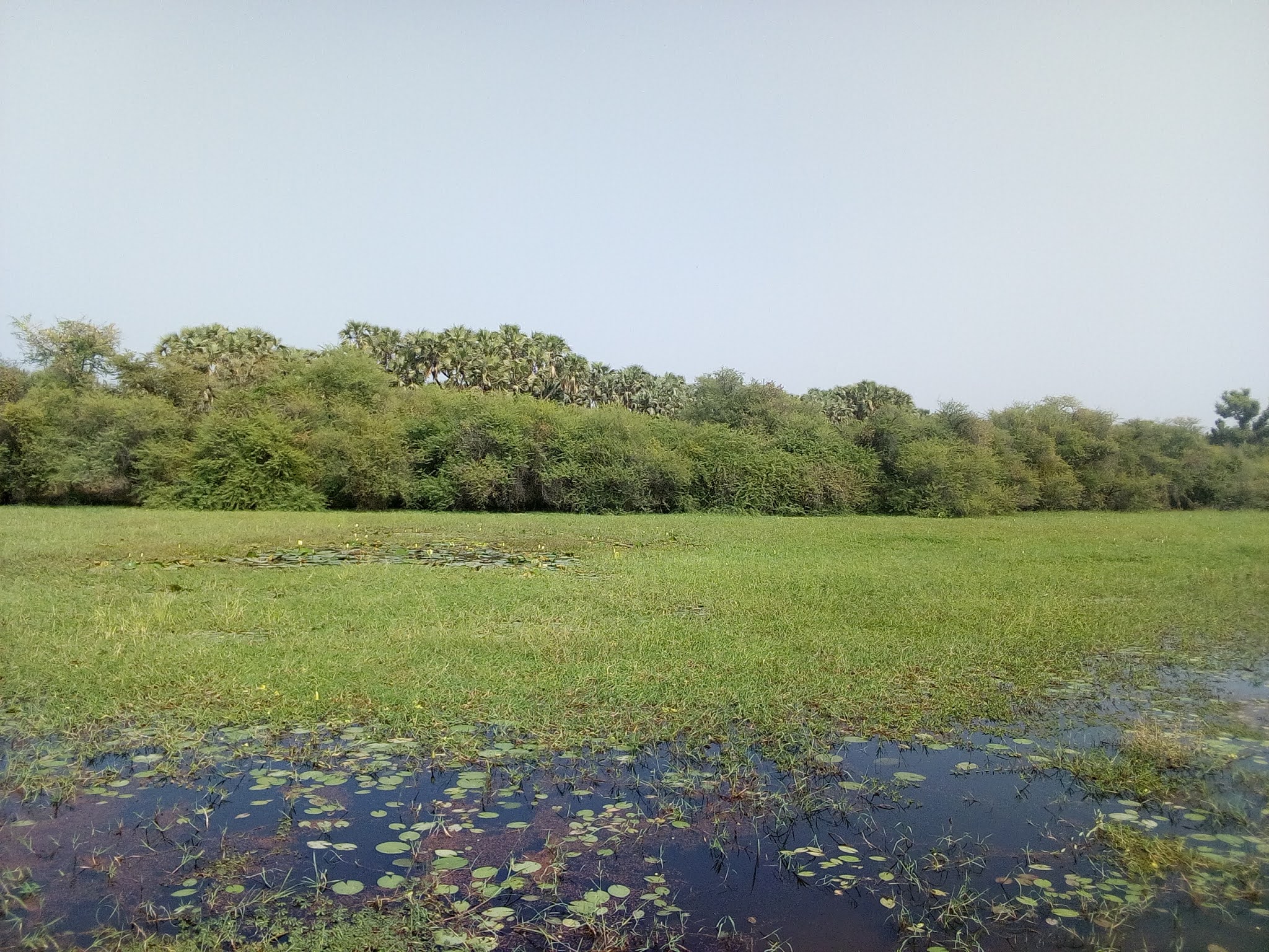
In Nigeria, the records indicate that the conception of large irrigation projects in the Hadejia area came as a result of a study conducted in the mid-1960s by the United States Bureau of Reclamation which was financed by the United States Agency for International Development (USAID). One of the analyses included the possibility of construction of several dams on rivers that drain the upper reaches of the Chad Basin through the Hadejia and the Yobe Rivers into Lake Chad. Moreover, the structural property of the Hadejia Valley Irrigation Authority (HVIA) which lies in the North-Eastern Kano State (now in Jigawa State) is a natural advantage for large irrigation project. The valley is about 5 miles wide and 20 miles long and lies between the Hadejia and Kafin Hausa River loop.  


However, the Hadejia River is the valley‘s northern boundary while the Kafin Hausa River borders the southern part. The valley area covered slightly more than 28,340ha (70,000 acres). Land formations within the project area, such as land dunes, lake bodies, and swampy areas as well as villages reduced the farming area to approximately 24,300ha (60,000 acres). During the Third National Development Plan (1975-80), the need for rapid production of food and industrial raw materials became obvious in the face of rapidly growing population and the experiences of devastating droughts. It was in this context that ―River Basins" concept came to be adopted.     


Accordingly, the Hadejia Valley Irrigation Authority (HVIA) was taken over by the Hadejia- Jama‘are River Basin Development Authority (HJRBDA) from the Ministry of Agriculture and Natural Resources (MANR), Kano State in 1976. The location of Hadejia Valley Irrigation Authority continued to be maintained as done by the MANR but, the original plan of small schemes in the projects at Agubu, Arawa, Ganuwar Kuka, Mai Alkama, Sunamu, Tashena and Yamidi operated by the ministry was renamed Hadejia Valley Irrigation Project (HVIP) and consolidated into two Phases (I and II). Operationally, Hadejia-Jama‘are River Basin Development Authority (HJRBDA) covers areas in Kano, Jigawa, and Bauchi States with a potential irrigable space of 250,000 hectares. The objectives of the authority among others include: harnessing, conservation, and efficient utilization of available water resources within its area of jurisdiction for increased agricultural production and domestic water supply (italics mine). The question is: How does the authority harnesses, conserves and efficiently utilizes the available water resources looking at the recent records on flood occurrences in the basin and beyond? This leads us to the upstream-downstream nexus.

UPSTREAM-DOWNSTREAM NEXUS IN THE VALLEY AREA


The Hadejia basin is located in the North Western part of Nigeria on the Hadejia River. It falls within geographical coordinates of 12º26’N and 10º04’E and has a drainage area of 25,900km2. The upstream section of the Hadejia River system lies on the largely impermeable Basement Complex rocks. The upstream Basement Complex region is hilly (with peaks of up to 1,200 m). Most of the flows in the Hadejia River system (80%) is regulated by Tiga Dam. The Hadejia River splits into three channels in the Hadejia Nguru Wetland: The Marma channel which flows into the Nguru Lake, the old Hadejia River which joins up with the Jama’are River to become the Yobe River and the relatively small Burum Gana River.


Nevertheless, the largest upstream irrigation scheme at present is the Kano River Irrigation Project (KRIP). Water supplies for the project are provided by Tiga Dam, the biggest dam in the basin which was completed in 1974. Water is also, released from this dam to supply Kano City.  The second major irrigation scheme within the river basin, the Hadejia Valley Project (HVP), is under construction. The HVP is supplied by Challawa Gorge Dam on the Challawa River, upstream of Kano, which was finished in 1992.  Besides, Challawa Gorge provides water for Kano City water supply. A number of small dams and associated irrigation schemes have similarly, been constructed or are planned for minor tributaries of the Hadejia River. 


In comparison, the Jama’are River is relatively uncontrolled with only one small dam across one of its tributaries. Plans for a major dam on the Jama’are at Kafin Zaki have been in existence for many years, which would provide water for an irrigated area totaling 84 000 ha. Work on Kafin Zaki Dam has been started and then stopped a number of times, most recently in 1994, and its future is at present still unclear. Therefore, Tiga and Challawa Gorge dams control 80% of the flows into the basin and are operated by the Hadejia-Jama’are River Basin Development Authority (HJRBDA) as stated earlier which is the nexus between up-and downstream of the river, and planning for the lower part of the basin is conducted by the Chad Basin Development Authority (CBDA). This shows that there are two major authorities as the dichotomy suggests.


However, a myriad of questions are: Is there a hydrologic boundary between the two- HJRBDA and CBDA? Is there a coherent, integrated development plan for the entire basin? Is there much coordination between the agencies responsible for the dams and those for water supply in the basin? Furthermore, is there a communication channel among the six states (Jos, Kano, Jigawa, Bauchi, Yobe and Borno) in the basin, the Diffa province in Niger within the basin and the federal planning and management authorities? How many agencies of government at various levels share some degree of jurisdiction over water management in the basin?  Do dam operators in the basin have inflow monitoring devices, inflow forecasting tools for the reservoirs? Is there a flood warning system for the basin?  What happens to the proposed river basins’  flood early warning system of 2009? (italics mine)

Nonetheless, based on the irreparable damages that have resulted from flooding in the basin, there is a dire need to direct urgent attention towards these and many more questions. Now let us look into the mechanism of flood management and control in Nigeria.


Management and Control of Flood in Nigeria  

The Government of Nigeria is the primary initiator of measures for the management of flooding in Nigeria. Various institutions, policies and regulations have been set up by government to address issues relating to floods and activities that promote/influence flooding in Nigeria. These agencies are:    


National Environmental Standards and Regulations Enforcement Agency (NESREA) 

This is an agency of the Federal Ministry of Environment that is saddled with the responsibility of enacting and enforcing regulations that protect the environment from degradation. Examples of some flood-related regulations are: 

i) Watershed, Mountainous, Hilly and Catchment Areas Regulations 2009: Aims to check and restrain activities in the above-mentioned areas that are inconsistent with proper land practices. 

ii) Wetlands, River Banks and Lake Shores Regulations, 2009: The objectives of these regulations are management and conservation of water catchments and flood control, conservation and sustainable use of wetlands and pollution control.  

National Emergency Management Agency (NEMA)  

The Nigerian government established the National Emergency Management Agency (NEMA) through (Act 12 as amended by Act 50 of 1999), to manage and respond to disaster related activities in Nigeria such as flooding, accidents caused by natural and man-made sources. NEMA is saddled with the responsibility of formulating policies, assessment of natural and man-made disasters, provision of mitigating measures for disaster related activities, coordinating plans and programmes for offering relief items to victims of such disasters. It is essential to assess the activities of NEMA as it relates to identification of flood risk areas in order to develop prevention/mitigation measures in controlling flooding in the area. 

National Erosion and Flood Control Policy (NEFCP) 

This agency was established in 2005 with the goal of protecting the environment from degradation, loss of productive land and negative impacts of flood. They are responsible for ensuring coordinated and systematic measures in the management and control of the hazards of erosion and floods to reduce their impacts on people and the environment.


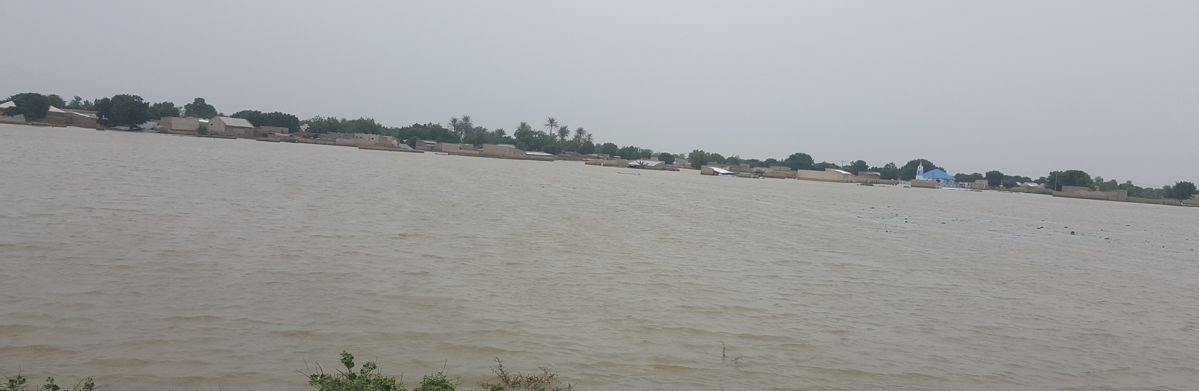
Since the inception of these agencies, policies and regulations, the country’s response to flood risk management has still been mainly that of relief management after a flooding incident. Even then, co-ordination of rescue operations has always been slow, exacerbating the damage and loss in the aftermath of the event. Part of this problem may be due to lack of technical expertise for handling environmental issues and insufficient information on flood vulnerability of different parts of the country, hence the need to introduce proven strategies to combat this menace. For instance, taking stock of flood occurrences in the basin 35, 500 people were displaced in 1988, also, it occurred in 1991, 92 and 93, 450,150 people were displaced in 2001 (Etuonovbe, 2011), 1.5 million farmers, herders and fishers were displaced (Nigerian Conservation Foundation, 2006), floods occurred in September, 2012, 15, 17, 18, and 19 (Legit Natural disasters in Nigeria: Top 5 of all times) and September, 2020.


THE WAY FORWARD

It can readily be acknowledged that dam development projects have played a very important role in advancing local and national economies thus, the fact that dam development projects can provide important local to national benefits, including benefits that flow to downstream communities is not at issue here.


Therefore, what is at issue is the degree to which dam projects degrade the natural food productivity of river socio-ecosystems and disrupt livelihoods and cultures dependent on these systems without an accurate accounting of these costs. 


Moreover, as described below, many of these negative consequences can be avoided by applying pragmatic 'best practice' approaches to overcome the recurrent problems of floods along the Hadejia Valley. The Hadejia-Jama’are River Basin Development Authority (HJRBDA) and the Chad Basin Development Authority (CBDA) should apply the followings:

  1. The need to identify, classify and map those areas subject to flooding as the basis for flood preparedness and management,

  2. The potential offered by remotely sensed radar photos to monitor and identify rapidly inundated areas, overcoming problems of overcast skies during flood periods,

  3. The use of GIS techniques to make inventories and analysis in a more systematic manner the impact of floods on agriculture and infrastructure,

  4. The urgent need to update the basin’s capabilities in flood forecasting and river modeling,

  5. The need to incorporate flood management as an integrated element in reservoir operation,

  6. The considerable potential of flood control works to offer more lasting solutions in flood management,

  7. The need to create a greater local awareness and preparedness in flood relief, mitigation and management,

  8. The potential for promoting dry season irrigation to offset yield reductions due to flooding, 

  9. Redesign of physical structures that cut across the basin such as roads with high bridges instead of culverts, dredging of old water outlets north of the basin that could serve as spillways and be utilised in the dry season, 

  10. The need for a proper institutional capacity at central and decentralized level to address flood problems on a continuous basis. For instance, coherent, integrated development plans for the entire basin, much coordination between the agencies responsible for the dams and those for water supply. Additionally, communication among the six states (Jos, Kano, Jigawa, Bauchi, Yobe and Borno), local government areas in the basin, the Diffa province in Niger within the basin and the federal planning and management authorities, and

  11. The need to collaborate with stakeholders which include: vulnerable communities resident in the hydrological, Community Based Organizations, Local, State and Federal Governments of Nigeria, Government Agencies and Institutions, the Private Sector, the Academic and Scientific Community, Non-Governmental Organizations, Regional Institutions and Organizations, and International Organizations.  


Otherwise, Hadejia Valley will be lost in development’s shadow as a result of the downstream human consequences of dams by taming the river. Thank you and remain blessed for reading and anticipate your response.

Mohammed Bashir Umar